Connect records to real-world locations and build a visual history of information across maps and plans.
Information is most valuable when people understand where it applies.
A photo of a defect, an environmental observation, a maintenance record or a site inspection may contain important details, but without location context it can be difficult to understand its significance. Teams often find themselves searching through reports, folders, emails and spreadsheets trying to determine where information was collected or what asset it relates to.
This problem becomes more significant as projects grow and information accumulates.
A single site can generate thousands of records over time. Without a clear connection to location, information becomes harder to retrieve, harder to understand and more likely to be overlooked.
GPS Linked Records solves this challenge by permanently connecting information to a real-world location.
Instead of storing information separately from the place it relates to, records remain linked to geographic coordinates, allowing users to immediately understand both what the information is and where it exists.
Most field information is location based by nature.
Assets exist somewhere. Defects occur somewhere. Inspections are completed somewhere. Environmental observations are collected somewhere.
Yet many organisations still manage information using systems that separate records from locations.
A spreadsheet may contain asset information but provide no visual context. A report may contain valuable observations but require users to manually identify where those observations occurred. Photos often become disconnected from the location where they were taken.
By linking records directly to GPS coordinates, information becomes easier to interpret and easier to access.
Users no longer need to rely on memory, file names or written descriptions to understand where information belongs. The location becomes part of the record itself.
Coordinates alone are rarely useful.
Latitude and longitude values may identify a position on the earth, but they do not explain what exists there or why it matters.
GPS Linked Records transforms coordinates into meaningful information.
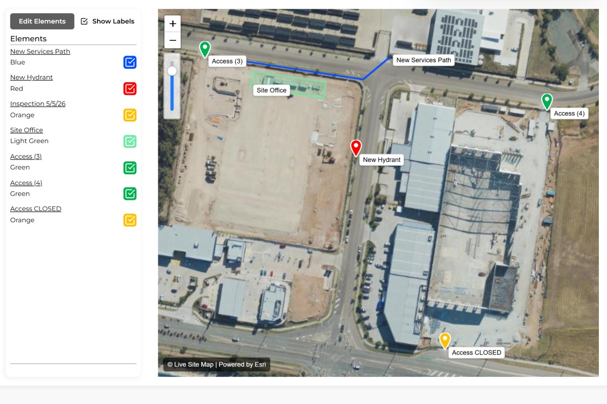
Each record becomes a location-based source of knowledge that can contain photos, notes, documents, observations, inspection results and operational information. Records can be viewed directly on satellite imagery, site plans and project maps, providing immediate context for field and office teams.
As information accumulates over time, locations become richer and more valuable. A simple point on a map evolves into a complete history of activities, observations and site knowledge.
This creates a visual record of what has happened, where it happened and why it matters.
Projects, assets and locations often outlive the people who originally worked on them.
Staff change roles. Contractors move on. Project teams are replaced.
When information is stored without location context, valuable knowledge is frequently lost.
GPS Linked Records helps preserve organisational knowledge by ensuring information remains attached to the location it relates to. Years later, users can return to a map, select a record and immediately access the history associated with that location.
This creates a more reliable and accessible record of field activities, inspections and observations.
Record inspection results directly against the location being inspected.
Store maintenance history against physical assets and infrastructure.
Capture issues and faults at their exact location.
Record observations, samples and monitoring activities geographically.
Maintain location-based records for pits, valves, conduits and network assets.
Store borehole, test pit and sampling information against collection locations.
Capture hazards, incidents and safety information where they occur.
Maintain a permanent record of activities performed in the field.
A GPS linked record is a record that remains connected to a geographic location through stored coordinates.
They provide location context, making information easier to understand and retrieve.
Records can contain photos, notes, documents, observations, inspection results and other field information.
Yes. Records can be viewed directly on satellite maps, plan overlays and location-based views.
Yes. GPS linked records are commonly used for asset management, inspections and maintenance history.
Yes. Multiple photos and supporting documents can be attached to records.
They connect information to locations, helping teams understand what exists, where it exists and what has occurred there.
Utilities, construction, environmental services, infrastructure management, geotechnical engineering and asset management organisations commonly use GPS linked records.


.jpg)
1234.png)