Capture photos, notes, observations and project information directly from the field and make it instantly available to your team.
Field information is constantly being created across construction sites, infrastructure projects, maintenance operations and field service activities. Photos are taken, inspections are completed, observations are recorded and work is documented. The challenge for many organisations is not collecting information, it is managing it effectively and ensuring it remains connected to the location where it was captured.
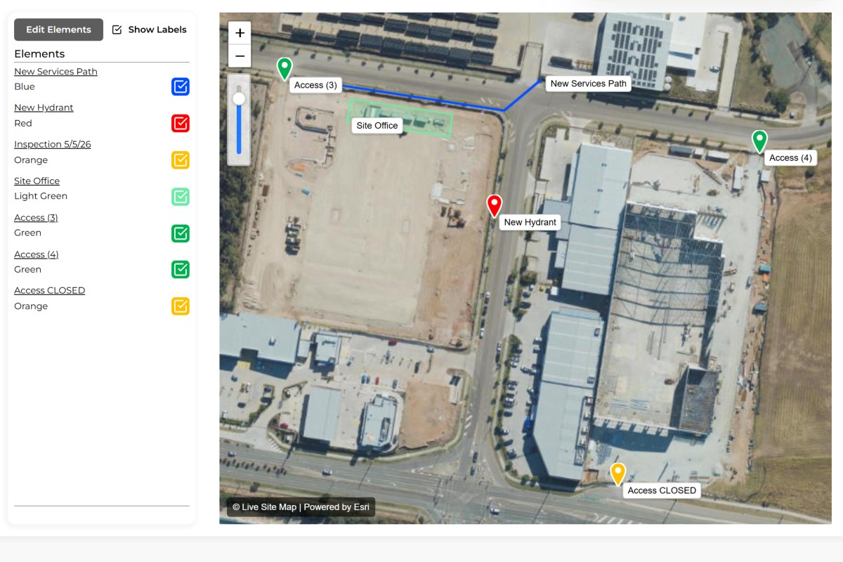
Live Field Records provides a simple way for field teams to capture and manage information as work happens. Instead of relying on notebooks, spreadsheets, emails or disconnected photo galleries, information is recorded directly within a shared visual workspace and linked to a specific location on a map or plan.
Each field record can contain photos, notes, documents, observations, inspection results, status updates and project information. Because records are linked to a location, users can quickly understand what the information relates to and where it was captured. This removes the need for lengthy explanations and reduces confusion between field and office teams.
Organisations use Live Field Records to improve communication, maintain accurate project records and provide visibility across ongoing operations. Information entered in the field becomes immediately available to authorised users, allowing supervisors, project managers and office staff to view the latest site information without waiting for reports to be compiled or paperwork to be returned.
The system works by allowing users to create a record, add information and save it against a location. Records can be viewed on satellite maps, site plans and project overlays, creating a visual record of activities across a site or project area. As work progresses, records can be updated, expanded and shared with the wider team.
Live Field Records is used across construction, utilities, environmental services, local government, infrastructure management and asset maintenance. Any organisation that needs to collect information outside the office can benefit from having a centralised and location-based approach to field documentation.
Many organisations still rely on manual processes to manage field information, creating delays, confusion and fragmented records.
Photos, notes and observations become difficult to locate once projects are completed.
Staff spend time describing where information was collected or where work was performed.
Documents, photos and field notes become separated from the locations they relate to.
Important information is often unavailable until reports are prepared and distributed.
Create a new field record from a mobile device or desktop.
Attach photos, notes, documents, observations and project details.
Save the record against a GPS location, map marker or plan position.
Provide instant access to field crews, supervisors and office staff.
Provide immediate visibility of field activities and site conditions.
Find records directly from maps and plans instead of searching through folders and emails.
Provide clear visual context for site information and project records.
Ensure teams have access to accurate information before making decisions.
Store field information within a shared visual workspace.
Maintain a clear history of inspections, observations and completed work.
Record inspection findings and site observations directly from the field.
Document completed work, milestones and project activities.
Capture issues and defects against their exact location.
Record maintenance activities, inspections and service history.
Document environmental observations, compliance checks and monitoring activities.
Capture hazards, incidents and workplace safety information.
Record work completed on infrastructure and utility assets.
Maintain accurate records of completed works and final site conditions.
Live Field Records are digital records that contain photos, notes, documents, observations and project information captured directly from the field.
They improve communication, reduce reporting delays and create a permanent record of field activities.
Yes. Records can include photos, documents, notes, observations and supporting project information.
Yes. Records can be linked to GPS locations and displayed on maps and plan overlays.
Yes. Records can be edited and expanded as work progresses.
Construction, utilities, environmental services, infrastructure management, local government and asset management organisations commonly use live field records.
Yes. Information can be made available to authorised users as soon as it is recorded.
They provide greater visibility of site activities, improve communication and help teams make decisions using accurate information.


.jpg)