Live Site Map helps environmental consultants manage field records, monitoring locations, site observations, photos, inspections, sampling points and project information in one shared visual workspace. Connect information to maps and plans so everyone knows what it is and where it is.

See how Live Site Map helps geotechnical engineers manage boreholes, test pits, site observations, photos and investigation records across a project site.
Environmental consulting is fundamentally location-based.
Whether conducting ecological assessments, groundwater monitoring, contaminated land investigations, vegetation surveys, rehabilitation inspections or environmental compliance activities, the work always starts with a location.
A monitoring bore.
A sampling point.
A vegetation plot.
A sediment control structure.
A rehabilitation area.
A water quality testing location.
A project boundary.
A protected habitat.
The location provides the context that gives environmental information meaning.
Without location, field records become difficult to interpret, compare and communicate.
Unlike many industries where work is completed and closed out, environmental projects often continue for years.
Monitoring programs may span multiple seasons.
Rehabilitation projects can run for decades.
Groundwater investigations may involve repeated sampling across numerous locations.
Environmental approvals often require ongoing inspections and reporting.
As projects evolve, information accumulates rapidly.
Field notes.
Photographs.
Sampling records.
Laboratory reports.
Site observations.
Inspection findings.
Compliance records.
Maps.
Drawings.
Environmental consultants are often responsible for maintaining information collected by multiple people over extended periods of time.
The challenge is ensuring future teams can understand what was recorded, where it was recorded and why it matters.
Most environmental consultancies have experienced situations where information exists but cannot be easily located.
A photograph was taken during a survey three years ago.
A monitoring point was inspected during a previous reporting period.
A site observation was documented in an earlier assessment.
A rehabilitation area was photographed before works commenced.
The information may still exist.
The problem is finding it.
Environmental records are often distributed across project folders, reports, GIS exports, spreadsheets, emails and personal devices.
Locating historical information can consume valuable project time.
Monitoring programs rely on repeatability.
Consultants need confidence they are returning to the correct locations.
Groundwater bores need to be identified accurately.
Surface water sampling points need to remain consistent.
Vegetation monitoring sites need to be revisited over time.
Rehabilitation inspections need to be compared against previous observations.
Small location errors can affect data quality and project outcomes.
Maintaining accurate location records helps ensure consistency across monitoring programs and reporting periods.
Environmental projects generate a large number of observations that may never appear in formal datasets.
Changes in vegetation condition.
Evidence of erosion.
Unexpected site disturbances.
Weed outbreaks.
Drainage issues.
Habitat observations.
Infrastructure impacts.
These observations often provide important context for future investigations.
Unfortunately, they are frequently captured in notebooks, spreadsheets or isolated project files.
When observations are linked directly to a location, they become part of the long-term site history.
Future teams can understand not only what was observed, but exactly where the observation occurred.
Environmental consultants rely heavily on photographs.
Photographs support assessments.
Photographs support reporting.
Photographs provide evidence of site conditions.
Photographs document change over time.
The difficulty is that large photo libraries quickly become difficult to navigate.
A project may contain thousands of images collected across multiple field campaigns.
Finding a specific photograph can be challenging.
Location-linked photo records create a visual history of a site.
Consultants can navigate directly to a monitoring location, inspection point or survey area and immediately access the associated records.
This approach improves both project efficiency and knowledge retention.
Environmental projects often involve a combination of field personnel and office-based specialists.
Field teams collect information.
Project managers coordinate activities.
Scientists analyse results.
Consultants prepare reports.
Clients review findings.
The challenge is ensuring everyone works from the same information.
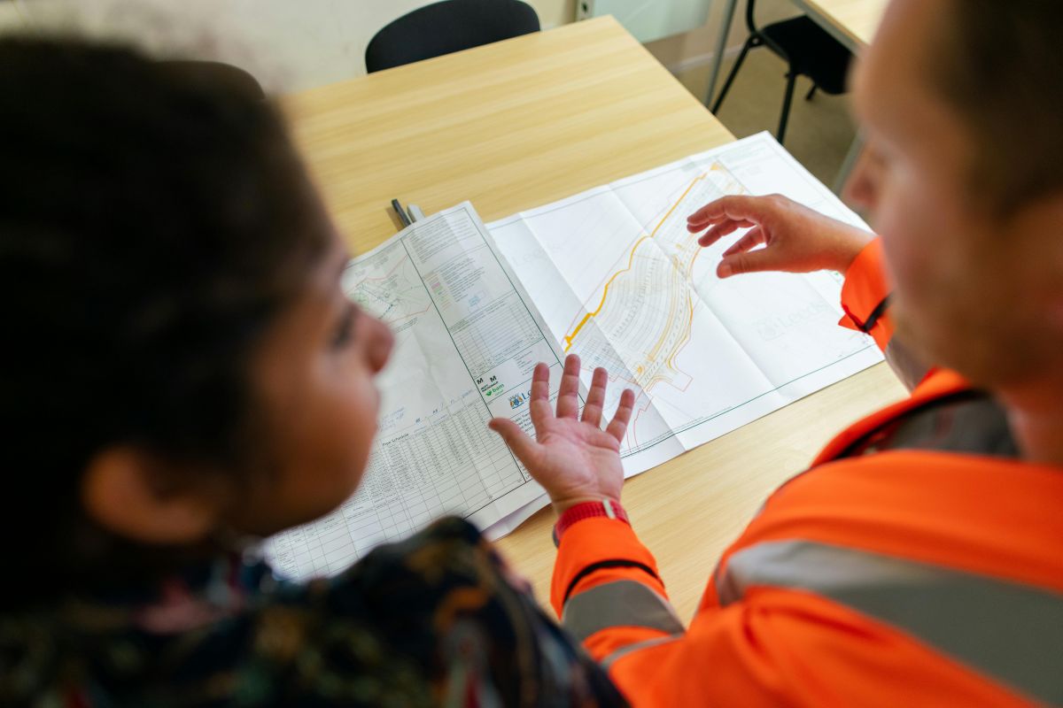
A shared visual workspace helps bridge the gap between field activities and office-based project management.
Instead of relying on lengthy explanations, teams can reference maps, locations and associated records directly.
This improves communication and reduces time spent searching for information.
Environmental projects rarely occur within a single building or construction site.
Consultants may be working across:
Information may be distributed across hundreds of locations.
Traditional folder structures often struggle to represent the geographic nature of environmental work.
A map-based approach provides a more natural way to organise and access information.
Teams can navigate geographically rather than searching through project directories.
Environmental reports are built on field information.
Observations.
Inspections.
Monitoring results.
Photographs.
Site assessments.
Historical records.
The quality of reporting often depends on how easily this information can be retrieved and verified.
When information is organised around locations, supporting evidence becomes easier to locate.
Consultants can quickly access the records required to support findings, recommendations and compliance reporting.
Environmental consultants manage information that is intrinsically linked to locations.
The challenge is not collecting data.
The challenge is maintaining the relationship between information and place.
Live Site Map provides a shared visual workspace where environmental consultants can manage monitoring locations, field records, site observations, photographs, inspections and project information through maps and plan overlays.
Teams can quickly understand what information exists, where it was collected and how it relates to the wider project.
Because environmental decisions depend on more than information alone.
They depend on knowing exactly where that information came from.
If you have any further questions or need assistance with Live Site Map, feel free to reach out to us anytime

If you have any further questions or need assistance with Akaunt, feel free to reach out to us anytime